


Geovelo : bike GPS app for iPhone and iPad
Developer: La Compagnie des Mobilites
First release : 16 Nov 2017
App size: 144.69 Mb
Geovelo, your free GPS application, your statistics and your challenges!
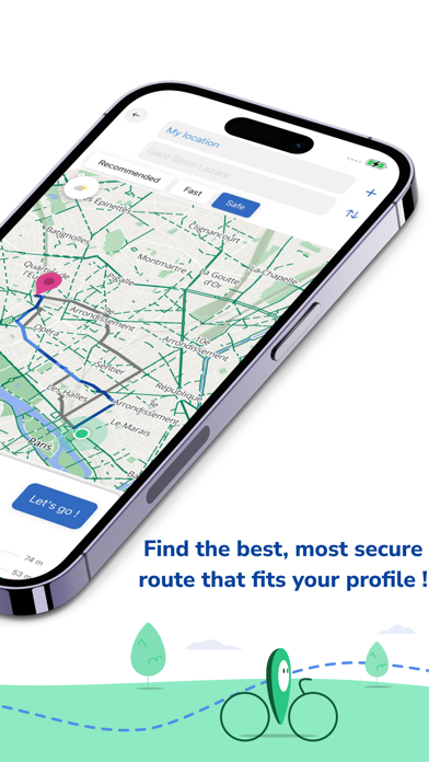
- PERSONALIZED ITINERARIES & GPS
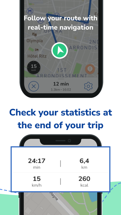
The app adapts to your type of bike (classic, electric, self-service (SSB), to your travel speed and to the type of route you prefer (from the fastest to the most secure). Geovelo prioritises cycle paths, cycle lanes and low-traffic streets to ensure your comfort, safety and peace of mind. Geovelo includes a real-time guidance system (map / full screen / compass mode), with voice guidance and notifications.
- STATISTICS & RECORDING
Log in and save your rides to access your personalized statistics.
When the Geovelo app is installed, you can start cycling around, and your routes will be automatically detected and saved. You can then view them in the app. Please note that you will need to authorise the retrieval of locations when the app is closed or in the background for this feature to work.
Geovelo allows you to synchronise your cycling activity information with the Apple Health app.
You can also use your Apple Watch to follow your itinerary or start a new trip.
- CYCLING FACILITIES AND BIKE PARKING
With its comprehensive mapping, Geovelo also allows you to quickly and easily find nearby bicycle parkings and bike racks.
- COMMUNITIES & CHALLENGES
Find other cyclists in your city or organisation, and connect by participating in regular activity challenges. Get on your bike every day or ride as many kilometres as you can to try and make it to the podium in your community! Note that several competitions are organised to win useful gifts for cyclists.
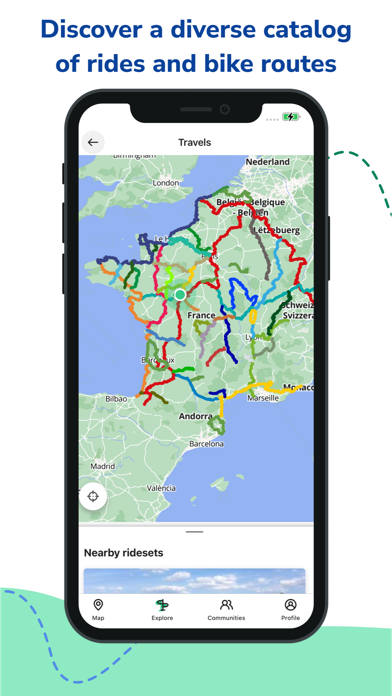
- CYCLE ROUTES & WALKS
The app also offers cycling routes (including La Vélodyssée®, Via Rhôna, La Loire à Vélo®, La Scandibérique, La Flow Vélo, Le Canal des deux Mers à Vélo, La Vélo Francette®, La Véloscénie, LAvenue Verte London-Paris and others) as well as numerous walks to discover the local heritages & treasures
- CONTRIBUTIONS & REPORTS
Report any missing bike-park, problems or roadworks, dangerous roads for cyclists and much more for the benefit of the community.
- PRACTICAL TOOLS
The application includes many features such as the display of cycling facilities, the setting of weather alerts on your favourite routes (to advise you on a departure time according to the weather), simplified address searches, etc.
- SELF-SERVICE BICYCLES
Geovelo displays the availability of bikes and parking spaces (BSS) in real time! In this context, we use data provided by companies such as Bordeaux V3, Vélolib, Vélo+, Donkey Republic, VLille, Velam, VéloCité, Villo, Velo2, Cristolib, VéloV, Le vélo, VéloCité, VélOstanlib, Bicloo, Cyclic, VélôToulouse, LE vélo STAR, PBSC, PubliBike V1, Yélo, Optymo, C vélo, Vélib, Vélocéa, Velopop.
- A CIVIC & VIRTUOUS APP
The data created from rides recorded with the Geovelo app is anonymised and used in the context of partnerships to help territories that we work with, to analyse and improve the cyclability of their network. It will never be used for marketing purposes. In addition, Geovelo actively contributes to the mapping of cycling facilities alongside the OpenStreetMap community (an international project to create an open map).
- LETS STAY CONNECTED
If you like this app, we invite you to rate it and tell others about it!
Follow @geovelofr on Twitter and Geovelo on Facebook to keep up with updates, news and the community.